Automated identification of archaeological sites using neural networks
AI-assisted virtual archaeological survey
Director: Steve Wernke, Arts & Sciences
Collaborators: Ralf Bennartz & Andreas Berlind, Arts & Sciences
About
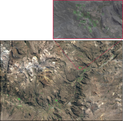
Archaeology contributes unique insights into the material and spatial dimensions of the human story, but big interregional networks in antiquity are notoriously difficult to document. Attempts to scale up traditional survey through multispectral Remote Sensing have met with limited success, because archaeological sites seldom produce spectral “signatures.” Advances in Convolutional Neural Networks (CNNs) in fields as diverse as medical imaging and astrophysics provide promising pathways to automated site detection, as CNNs can learn to identify the distinctive features of objects in images. However, CNNs require thousands of training images labeled by people to learn the shape properties of archaeological features. We are now collecting large scale virtual survey data using teams of collaborators using GeoPACHA: Geospatial Platform for Andean Culture, History, and Archaeology.
Automated relict architecture detection using convolutional neural networks
Research Goal: By creating tools to build these training datasets, we will execute CNN-based automated archaeological survey on an interregional scale in Andean South America.
Methods: GeoPACHA was developed in collaboration with co-editor Parker VanValkenburgh (Brown University) through grants from the American Council of Learned Societies, NEH, and CAST. GeoPACHA immerses students in archaeological discovery as they learn to identify archaeological sites over tens of thousands of square kilometers. The thousands of sites identified with GeoPACHA will be used to train a CNN-based autonomous survey platform.